Showing posts with label wildflowers. Show all posts

Wednesday, July 25, 2018

Wasatch Wildflowers: Abies lasiocarpa, Sub-Alpine Fir


Perhaps among the most distinguishing features of this fir tree is the upright presentation of dark purplish cones early in the season.  The cones exude sticky sap that drips down.


The bark of mature trunks of the tree is smooth gray, punctuated with elongated lenticels and minor branch scars, which give it a stippled appearance.


The crown of mature firs present as a sharply pointed and gradually tapering pyramidal shape, typically with major branches reaching to the ground, or nearly so


.

Firneedles adopt a very dark green color overall, with the new growth appearing much lighter in color.


On close examination, in can be seen the needle is pyramidal in cross section, and that the needle surface is densely packed with white lenticels on either side of the needle midrib, with the upper surface less dense and the lower white stripe being wider.


Interesting to note that the Sub Alpine Fir at the highest elevations adapts a "Krumholtz" growth habit, the trees presenting stunted and twisted shapes with little height, sometimes even reduced to mat-like prostrate and ground hugging growths that bear scant resemblance to trees at lower elevation.


Wednesday, April 08, 2015

Wastch Wildflowers


Wasatch Wildflowers.

I have been identifying the profusion of mountain wildflowers from A to Z, from photographs submitted by the Hike the Wasatch club over a number of years.  The mountains of Utah become a summer showplace of superlative splendor.   This YouTube slide show is another form of home movies, though the accompaniment is courtesy of the Vienna Philharmonic and first movement of Beethoven's 9th.  The sequence follows more-or-less alphabet sorting of the taxonomic genus names.

Monday, February 16, 2009

Utah Places: Lake Fork

Lake Fork from Thistle Junction to Indianola is a hidden treasure. The area doesn't bear too much traffic -- just mostly from curious passer bys or those already in the know. But every once in a while, some less intrepid back roads explorer ends up coming across the old Thistle Junction and the Lake Fork that it hides, and they discover a new world of wonders.

At the bottom of the road is located the cause of a tremendous saga in Utah State history. The Thistle slide was a geological event on a global scale of unprecedented proportions. A largely forgotten event now, at the time, just the roadwork to relocate US89 above the flood was a heroic project, needed to restore interstate transport through the area that was interrupted for more that 18 months.

At Thistle Junction, there is a monument erected to commemorate the event that took place over 1981-1983. There are lots of good web resources, like this Wiki entry HERE.

At the west end of the old US89 remnant on the Thistle side, a Utah County Sheriffs facility has appropriated the slide to use for shooting practice. It is all fenced off with tall fences and barb wire. Don't try to go in there.

The ruins of the old Thistle school/common building is private property now, so please just look and admire. It is still a great photo op. Don't look for souvenirs or anything touristy like that, please. Definitely bad form. Photos only.

Across the highway and over the big culvert, the Lake Fork Road starts in earnest. Lots of off-road ATV and motocross enthusiasts never make it past this point at all. In fact, there is a sort of shirt-tail RV-park on private land just at the foothill of the mountain here, that offers access to the Forest Service property beneath the high-tension power lines that run across here and beyond. The foothills scrub and oakbrush area are criss-crossed with trails that lead everywhere and nowhere -- an off-road vehicles wet dream. I personally think they are ugly scars on the land, but if you like that sort of thing, this is the place to come. And ENJOY! That is the nice thing about this land, there is room enough for everyone to spread out without crowding, and do their own thing.

Further along the road, there are several places that are private lands along both sides of the road. Please respect ranchers signs and fences and do not disturb historic artifacts or grazing livestock. None of these things are there for your amusement or entertainment. Someone else went to the expense and the bother to fence their land and raised the stock and built the buildings. Leave them as you find them. If gates are locked, assume that someone intended them that way for a purpose, and either take the time to inquire, or leave them alone.


You may not find any signs quite like this one, but if you do find plain old "no trespassing" notices, please respect them. They're serious, and so am I.

Further along, you will finally come to some nicer signs informing you that you are welcomed to Forest Service boundaries, in the Manti La-Sal Division. This is good news, that you have made it this far. You might have encountered a few minor obstacles along the way -- downed logs across, flooded, boggy areas, mud holes, rocks, etc. All just part of the fun. Don't worry, it will get worse. If that worries you a lot, better turn around now. If you think we're just getting warmed up, drive on.

The road follows Lake Fork and continues to climb alongside it's course. This is the most remarkable thing to note about this drive. It starts in sagebrush scrub, progresses higher to pinion/juniper, through Doug fir and on up to White fir and Engleman spruce and limber pines, at the very peaks. The progression of ecosystems is very orderly according to exposure and elevation. Remarkable and very instructive to see.

Just past the first signs, there are organized camp sites here and there along the creek. I have never taken much note or interest in any of them. If you are particularly in need of such a facility, please consult the Forest Service for more info. Or follow this link.

I have seen many groups, some appear to be camping, fishing, or ATV riding, or family gatherings, or what have you, camped in more informal areas under the trees along the creek. I assume this is absolutely okay too -- I have never seen rangers rousting anyone minding their own business. So if you have a mind, feel free to set up a camp where ever strikes your fancy. Keep in mind that space is more at a premium generally, as you progress to higher elevations. So as a rule of thumb, big flat shady spots are best found nearer the Thistle end of the road. Not too low down -- get far enough up the creek to beat the heat -- but not so far up the mountain that there's no flat level spots left to park your rigs.

That said, I have to say, one of my favorite picnic spots is pretty high up the canyon, beneath a stand of very old tall Doug firs with thier feet speed out broad. There's enough space underneath to spread out a few picnic lunches on blankets on the ground, and the creek meanders by to the east for the children to paddle and play in. A side-canyon adjoins and beckons the boot-leather anxious adventurer, and I have hiked it for many miles, but I will not spoil the suspense, for any who wish to try it themselves. Look for some interesting fossil specimens, if you're into that sort of thing. I found some in a ridge on the north shoulder, in rocky outcropping.

For that matter, if you don't want to walk so far, just look carefully in the creek.

Higher up, there is a big switchback. and very steep bit of climbing as the creek tops out. Note that along the way a couple of miles back, you passed by the fork to the west leading to Smith's Reservoir. It qualifies as more of a big pond, in my book. Some people swear the fishing is phenomenal -- I have never tried. It is a nice short strenuous hike, or a very hairy 4wd trail, or an easy short ATV adventure -- take your pick. I have only hiked, cross-country from the southern approach. It makes an interesting trek from the Buggy Wheel Springs area.

Also, west of the road and south of the little reservoir is the summit area of the Lake Fork. It consists of a series of rock pinnacles and rocky ledges, with White fir and Limber pines all around the shoulders. These rocks host some fun scramblin on bouldering and mixed talus and steep gravel slopes. It is a big reward to top out on one of those little peaks, and just look around. I once carried a directional 2 meter radio rig with me, but was unable to make a contact. Sanpete County is pretty dead in the middle of the day.

Another fascinating feature of the middle elevations in this particular area is that it hosts a lot of the species Cercocarpus ledifolius. For those of you in Rio Linda, this is the Curl-leaf Mountain Mahogany, and the reason it is very interesting to people who love the mountains, big-game hunters in particular, is because Curl-leaf is one of the primary winter forages of the species Cervis canadensis, the Rocky Mountain Elk. One of the most prized of big-game animals in this area. Very few hunters come seeking this animal here, and they seek these rocky pinnacles, perhaps as a refuge.

My neighbor bags his regularly in a small valley just to the south on the Indianola side. But perhaps I am giving away too many secrets.

A few years ago, when I was more able, I was hiking cross-country from the US89 side out across the pinnacles area, through the Buggy Wheel Springs access. See the Birdseye comment for more detail about that area. Anyway, as I approached the pinnacles from the west, I was watching the elk. I stayed far enough away that I did not think I would spook the herd, but they obviously spotted me moving in  the scrub, and started browsing away. Suddenly I noticed a WHITE animal, far on the outskirts of the herd. It was a very large herd at the time, several hundred animals, more than I could reliably count heads with my field glasses, because they were moving. But the one animal was so obviously WHITE from top to bottom that he stood out starkly in contrast to the others.


Apparently, he was albino. I watched until they browsed across the ridge and I could no longer see them.

One of the most remarkable things I noted while watching the herd was that they seemed to shun the albino member. He stayed on the outskirts of the grazing area, and the other animals shoved him or shouldered him away when he attempted to graze into the area where they were browsing. I didn't watch long enough to make any real conclusions or studies other than casual observation, but if I was making a guess, I would say that the other animals of the herd discriminated against this white colored animal because he was superficially different from them.

Draw your own conclusions.


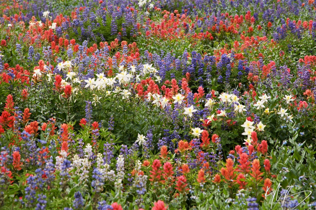
One of the chief among reasons I go back to the Lake Fork again and again is for spring wildflowers. Let me show some specifics, just to tantalize the few sceptics.

One of my big favorites is the Aquilegia canadensis, the wild columbine flower. Colorado thinks it is their state flower, so we will just keep the Utah specimens our little secret -- lots of them grow here, too.


In the higher, wetter areas of Lake Fork, look for them blooming in late spring on stream banks in the shade. They are the crowning beauties of the forest.

You will also find, in almost opposite circumstances, two species that I also love to find that represent the freedom of the hills.

The Gilia aggregata is an example of a wildflower nature has adapted for the worst conditions. Scarlet gilia thrives in rocky dry waste places where little else can grow.


It often flowers on rocky steep hillsides and roadcuts. Watch for sprigs of bright scarlet colors where they almost cannot be, it will probably be scarlet gilia.

In a properly shared ecosystem, the hot dry sandy west-facing hillsides heat up too fast for almost everything except that intrepid species Oenothera ceaspitosa, the evening blooming desert pale primrose.


It roots deep in sandy hillsides and displays its showy blooms against the dull backdrop canvas of plain hot sands. It is a good showing, and a fragrant one.

There are many other wildflowers to be found and marvelled in, in the Lake Fork area and throughout the Wasatch. Look for them. Stop and smell the flowers. It will bring everlasting joy to a dreary world, and enliven your heart, as it has mine, I promise you.

One last species, to make good on this special promise, that holds a special place for every true Utahn. Calochortus nuttalii, the Sego Lily, is the Utah State flower, and for good reason. This stalwart gem is a practical and beautiful little blossom that blooms on highlands and high desert lands throughout the west.


It is truly a shining picture of practical persistence and splendor amid harsh conditions everywhere -- a good example and uplifting inspiration to us all.

Saturday, February 14, 2009

Utah Places: Mount Nebo

Nebo is seen from the freeway by travellers and is probably the most prominent landmark on the Wasatch Front that may get the least credit as a spectacular place to visit.

There are so many good things to list, I hardly know where to start.

One of the most interesting for boot-leather enthusiasts is that Nebo is a great place to hike. My favorite is starting from the Bear Canyon area, climbing up one of the many shoulder ridge trails to the summit ridge, and along to one of Nebo's summits. Nebo is actually a rather long, narrow north-south ridge with several "summits" of substantial height. They're all kind of crumbly talus decomposing sedimentary rock, loose and sliding, so the trails are pretty informally defined. If you actually find yourself so high, look west and find Nephi and Mona down below your feet, and Utah lake stretching out further to the west and north, with Payson/Santaquin just below to the right, Spanish Fork further, and Provo/Orem sprawling offinto the far distance on the north, Santaqin Peak and Loafer Mountain northeast, and west the other of side the Lake Mountains, out into parts of the West Desert, south to the mountains down the Wasatch chain in the Red Cliffs area and further, and east across to Baldy and the Skyline on the Wasatch Plateau. Nebo also has a good summit trail coming fairly straight up from the Nephi/Mona side, but I have never hiked it.

On the scenic menu, Mount Nebo shelters a Bryce-Canyon-like formation called Devil's Kitchen.


Okay, it's not Bryce Canyon, but it is beautiful, and worth the time to look.

Also on the regular drive across Nebo that is billed as the "Nebo Loop" is Payson Lakes, which is a marvellous place for a Sunday afternoon picnic or a short holiday drive in the mountains, or to come to see the autumn leaves, or whatever.


Payson Lakes is one area that has become popular enough to assume Disneyland proportions, so there is a blacktop track paved around the main lake for the benefit of joggers, bikers, walkers, stroller, what have you. Don't let it bother you, its overall a good thing.

If you just love camping with you family in campgrounds, there are some of the best around on or around the slopes of Nebo. I personally love Blackhawk. My preference. There is also Bear Canyon, if you love big cottonwoods and tall evergreens. It's on the south side, Blackhawk is northeast, so they give different perspectives at different times of year.

There are other campgrounds further off the beaten path that you can search out. I'm not going to name any here, because the people that use them think they own them. Maybe they do.

Personally, I would prefer to depart from the road by a wide margin and camp somewhere in the tall weeds. But I know this is not for everyone. I like hearing coyotes howl at the moon on the ridge after midnight, and owl hoots early in the morning before sunup. I want to find the snake trail across my path and the spider web in my boot. Ants in my granola are okay, I'm just more careful to keep the package closed next time.

Using a tree for bathroom needs has turned into a major problem for me. My last outing on our Milford Flats project, I had several accidents, and only an understanding and patient partner (with a not too sensitive nose) kept me from big-time breaking down out of just plain humiliation. Dealing with this kind of thing is a regular fact of life issue for families with babies and young children, and to a lesser degree, some adults are simply less comfortable or less adept. Using public facilities has always been emotionally uncomfortable for me, and now there is the hazard of unknown communicable germs ever present. It is a difficult problem, made worse by circumstances some of us cannot help. Under my present handicap, I found that under urgent need, I just could not physically get out of the tent, unencumbered from sleeping bag and other paraphernalia in time, and as a result, was unable to stop myself from peeing all over my person and my bedclothes. I do not know what exactly to recommend, and am hoping for some good suggestions. Other than carrying a shovel and a good supply of wet-wipes, I am a beginner.

Wednesday, February 11, 2009

Utah Places: Albion Basin

Should I put this one on the list?

Albion is by far one of the favorite spots in Utah. In fact, we love it to death. I am afraid too many people go there when the flowers are blooming, and the Forest Service encourages them.

There is a long dirt grade climbing up the hill to Albion from the Alta parking area, and sometimes it is choked with cars and dust.

Of course, the destination from Albion was always the Cecret Lake Trail. The lake is an alpine gem a short hike above the parking area at Albion.


 Cecret Lake

It is beautiful beyond compare. Like all alpine lakes, the water is cold and crystal clear. The air is crisp and clean, even in mid-summer. Crowds of people don't seem such a bother. But the area is generally crowded all the time now, to the point that it is difficult to find a parking place in Albion anymore during weekend hours.

I fear for tomorrow.

For me, at least, that spoils some of the enjoyment of what wilderness should be. What can we do? I don't know? It worries me. Someday I think it will become more like Disneyland.

I will never go there again.

That will be a sad day.

Utah Places: Wasatch Mountain State Park


You can make a free and beautiful traverse between Salt Lake Valley, Heber, the ski resorts, and Park City. All summer long. Not many use this road, and its a good thing. It summits over Guardsman’s pass, and there are trails connecting in every direction, including connections from American Fork Canyon, Heber Valley, Cascade Springs, and other locations along the Wasatch. The roads are only good enough for light traffic, but ideally suited for vehicles like the 4runner. A more spectacular vista of the skyline all around cannot be found anywhere. Be sure to wear cold weather gear -- its always cold and windy up here.

Good place for a Sunday afternoon drive to look at wildflowers. All the side canyons along the way compete for the best.

More info here.

Utah Places: Alpine Loop

There isn't a photo that does any part of it justice. The entire loop is a tour of magnificence, either direction you approach from, the Alpine side, or the Sundance side.
 A Profusion of Wildflowers


 Wyethia


Timapnogos is the crowning centerpiece throughout the drive. Around every corner there are sights and scenes of wonder to behold.


 Epilobium


Every season the tableau changes. From spring to summer through fall, there is never a day that the scene is the same. The road closes sometime early in the winter, whenever county snow plows can no longer push their way safely through the deepening drifts. Then they abandon the road until next spring to the ski touring and snow machines.


The mountain itself is so loved and so popular, there are hundreds of attractions on the sides and within the near vicinity. I will only list a few of the less visited and rarely known. The others, you can find yourself as you wind around the foot of Timp, working your way over that venerable old shoulder.

Utah Places: Cascade Springs


Cannot find any photos that really do a bit of justice to the magnificence of this natural beauty. It has been loved by so many visitor through the decades, and enhanced by the addition of the walkway surrounding the quiet flowing springs and pools that spring right up from the rock.

Lush vegetation and abundant flowers through an extended growing season are th exceptional attraction, as well as many water-borne species not seen in such collections anywhere else.

If there was ever a natural setting for an afternoon walk more at peace with nature, more conducive for reflective thought, better for having the kids race each other around in circles to exhaustion, and fine fried chicken picnics, I cannot think of a place.

Links are plentiful, try here.

Tuesday, February 10, 2009

Snow in Sanpete

Snow so far this season is about average as it goes. I am not getting out much, but this SNOTEL plot from the Mammoth-Cottonwood site up Fairview Canyon shows the story for so far this year. The dark blue line traces Snow Water Equivalent, which is very near but just below the ten-year average, probably because it has been warmer than normal on the Skyline so far. The Total Precipitation, the dark red line, shows well ahead of the ten-year average, shown by the yellow. So our water year is off to the very best of starts.

The snow pack is not as deep as in some years, because the melt rate has been higher due to warmer temps, but the water is there, to water crops and gardens next spring.

And to make the wildflowers blossom.


This specimen is Palmer's Penstemen (Penstemen palmeri) BTW. It is a common but sparse resident of Sanpete County in late spring and early summer at elevations ranging from 3000 to 6000 feet at roadside waste place with little extra water and dry sandy soil.

Sunday, February 08, 2009

Utah Places: Uinta West Side Meadows and Lakes

Mirror Lake and China Meadows are good examples. There are countless others less crowded or with slightly different character. What are you looking for? Trial Lake is good for fishing. Wall Lake is a great fishing spot, in addition to spectacular scenery and a short hike.

Mirror Lake is good scenery and good car camping, right off the highway. Crowded, though.

Christmas and China Meadows host an incredible array of wildflowers in season. Wildlife in abundance. Birds flocking through. And always hoards of chipmunks and squirrels scurrying around.  You might spot an elk or some deer, or even a moose!